A subscription to JoVE is required to view this content. Sign in or start your free trial.
Method Article
Measuring and Mapping Patterns of Soil Erosion and Deposition Related to Soil Carbonate Concentrations Under Agricultural Management
In This Article
Summary
Spatial patterns of soil erosion and deposition can be inferred from differences in ground elevation mapped at appropriate time increments. Such changes in elevation are related to changes in near-surface soil carbonates. Repeatable methods for field and laboratory measurements of these quantities and data analysis methods are described here.
Abstract
Spatial patterns of soil erosion and deposition can be inferred from differences in ground elevation mapped at appropriate time increments. Such changes in elevation are related to changes in near-surface soil carbonate (CaCO3) profiles. The objective is to describe a simple conceptual model and detailed protocol for repeatable field and laboratory measurements of these quantities. Here, accurate elevation is measured using a ground-based differential global positioning system (GPS); other data acquisition methods could be applied to the same basic method. Soil samples are collected from prescribed depth intervals and analyzed in the lab using an efficient and precise modified pressure-calcimeter method for quantitative analysis of inorganic carbon concentration. Standard statistical methods are applied to point data, and representative results show significant correlations between changes in soil surface layer CaCO3 and changes in elevation consistent with the conceptual model; CaCO3 generally decreased in depositional areas and increased in erosional areas. Maps are derived from point measurements of elevation and soil CaCO3 to aid analyses. A map of erosional and depositional patterns at the study site, a rain-fed winter wheat field cropped in alternating wheat-fallow strips, shows the interacting effects of water and wind erosion affected by management and topography. Alternative sampling methods and depth intervals are discussed and recommended for future work relating soil erosion and deposition to soil CaCO3.
Introduction
Soil erosion threatens the sustainability of agricultural lands. Crop management, such as a conventionally-tilled winter wheat-fallow crop rotation, can accelerate erosion and deposition processes as bare soils during fallow periods are more susceptible to wind and water forces1,2,3,4,5 (Figure 1). While these processes might be evident, they can be difficult to quantify.
The purpose of this study is first to provide an efficient method for quantifying and describing spatial patterns of erosion and deposition at the field scale using global positioning system (GPS) technology and geographic information systems (GIS) mapping tools. A simple conceptual model relating these patterns to near-surface soil carbonates (CaCO3) is also presented and tested by prescribed field and laboratory methods. These relationships provide indirect measures of erosion and deposition, while validating the results of the GPS method. The present paper emphasizes the methods used in Sherrod et al. so that they can be repeated, in part or whole, for similar research in other locations6.
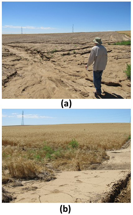
Figure 1. Photos of (a) Erosion and (b) Deposition at the Study Site Following a Heavy Rainfall Event. A tractor tire track in the lower right corner of photo (b) indicates the depth of deposition at the wheat/fallow strip border.
Various direct methods for measuring soil erosion were reviewed by Stroosnijder7. Suggested methods vary with the measurement purpose and resources available, but a "change in surface elevation" method is recommended at the hillslope scale and provides the advantage of measuring both erosion and deposition. One way to apply this method is to install pins in the soil and monitor the change in height of the soil relative to the top of the pin7. With advances in land surveying technology, however, this labor-intensive approach can be replaced by other techniques, such as terrestrial laser scanning (TLS)8,9,10,11,12,13,14,15,16, airborne laser scanning (ALS)17,18,19,20,21, GPS6,22, advanced photogrammetry23,24, or combinations of these techniques25,26,27. While laser scanning, commonly referred to as LiDAR (Light Detection And Ranging), provides the most rapid acquisition of dense surface elevation data sets, corrections must be made to remove standing objects, such as vegetation. With millimeter-level vertical precision, TLS can detect the smallest elevation change, however Perroy et al. recommended ALS over TLS for gulley erosion estimates due to the larger scanning footprint and better instrument orientation (less topographic shadowing) for scanning into deeply incised gullies28. Real-time kinematic GPS (RTKGPS), providing centimeter-level precision without data post-processing, is used for this study. The spatial resolution and precision of RTKGPS-collected data are optimal for detecting the dominant erosional and depositional features in an agricultural field or other environments with substantial ground cover.
The pressure-calcimeter method for quantifying soil CaCO3 relies on the soil's reaction to acid in a closed system, resulting in the release of CO2. The increase in pressure within the reaction vessel at a constant temperature is linearly correlated to the amount of soil CaCO329. Modifications to the traditional pressure-calcimeter method, described by Sherrod et al., include changing the reaction vessel to serum bottles and using a pressure transducer wired to a digital voltmeter for the detection of pressure changes30. These modifications allow for lower detection limits and a higher capacity for daily soil sample runs. Gravimetric or simple titrimetric methods for soil CaCO3 measurement produced larger errors and detection limits than this modified pressure-calcimeter method30.
Conceptual Model
When direct measures of erosion and deposition are not feasible, indirect indicators of these processes may be used. Sherrod et al. hypothesized that soil surface layer CaCO3 concentration in a semi-arid climate is inversely correlated with the change in ground surface elevation (positively correlated with erosion, negatively correlated with deposition)6. The hypothesis should apply broadly, but specific relationships will depend upon site conditions (soil, vegetation, management, and climate). Soils at the test site (Table 1) typically contain a distinct calcareous layer 15-20 cm below the soil surface. Conceptually, erosion will remove the surface layer of relatively low CaCO3 concentration leaving this calcareous layer of high CaCO3 closer to the soil surface. The low CaCO3 soil is then transported to the depositional areas, causing the calcareous layer to be buried deeper below the soil surface (Figure 2). Sampling these soils over time at appropriate depth intervals, either erosion or deposition (or neither) may be inferred by CaCO3 concentration, according to this model.
| Soil Series | Slope | Taxonomic classification | Depth | pH | EC | Total N | SOC | CaCO3 |
| % | cm | 1:2 | dS m-1 | g kg-1 | g kg-1 | g kg-1 | ||
| Colby loam | 5-9 | fine-silty, mixed, superactive, calcareous, mesic Aridic Ustorthent | 0-15 | 8.2 | 0.24 | 0.7 | 6.1 | 69.8 |
| 15-30 | 8.3 | 0.24 | 0.5 | 4.0 | 84.3 | |||
| Kim sandy loam | 2-5 | fine-loamy, mixed, active, calcareous, mesic Ustic Torriorthent | 0-15 | 7.8 | 0.26 | 0.8 | 7.0 | 29.8 |
| 15-30 | 8.0 | 0.27 | 0.6 | 5.0 | 51.5 | |||
| 5-9 | fine-loamy, mixed, active, calcareous, mesic Ustic Torriorthent | 0-15 | 8.1 | 0.22 | 0.6 | 5.4 | 26.7 | |
| 15-30 | 8.1 | 0.19 | 0.5 | 4.1 | 25.8 | |||
| Wagonwheel loam | 0-2 | coarse-silty, mixed, superactive, mesic Aridic Calciustept | 0-15 | 8.2 | 0.23 | 0.7 | 5.9 | 66.2 |
| 15-30 | 8.2 | 0.23 | 0.6 | 3.7 | 98.1 | |||
| 2-5 | coarse-silty, mixed, superactive, mesic Aridic Calciustept | 0-15 | 8.3 | 0.23 | 0.8 | 6.6 | 52.0 | |
| 15-30 | 8.4 | 0.26 | 0.7 | 5.4 | 118.3 |
Table 1. Soils at the Test Site. Soil mapping units and taxonomic classification, with average soil pH, electrical conductivity (EC), total N, soil organic C (SOC), and CaCO3 concentrations in the 0- to 15- and 15- to 30-cm depth increments for the Scott field in 2012 (from Sherrod et al.)6.
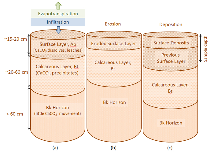
Figure 2. Conceptual Soil Profiles. Conceptual soil profiles for (a) a static soil matrix with CaCO3 leached from the surface layer and precipitated in a deeper layer, (b) moderate erosion of the surface layer, and (c) moderate deposition of material above the previous surface layer. Depth intervals (left) are approximate based on site data (from Sherrod et al.)6. Please click here to view a larger version of this figure.
Site Description and History
The 109-ha Scott field is part of the Drake Farm in northeastern Colorado (40.61oN, 104.84oW, Figure 3) and was monitored from 2001 to 2012 for this study. Average annual precipitation and evapotranspiration were approximately 350 and 1200 mm, respectively, in this semi-arid climate, where convective rain of short duration and high intensity were common during the summer. Elevations range from 1559 to 1588 m in this undulating terrain with distinct landscape positions: summit, sideslope north-facing (side-NF), sideslope south-facing (side-SF), and toeslope (Figure 4b). Alternating strips (~120 m wide) were typically managed in this rainfed winter wheat-fallow rotation such that every other strip was fallow for about 14 months out of every 24-month rotation cycle. Shallow tillage (~7 cm), typically v-blade sweeps, occurred 4 to 6 times through the fallow period for weed control. Soils at the site were classified to have a soil-loss tolerance, or T value, of 11 Mg ha-1 year-1, where erosion rates below this T value are considered acceptable for continued agricultural production4.
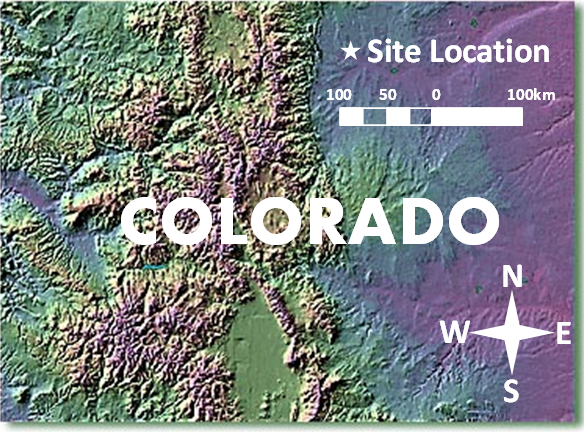
Figure 3. Site Location is Shown on a Topographic Relief Image (1011 to 4401 m) of the State of Colorado, USA. Mean elevation of the site is 1577 m.
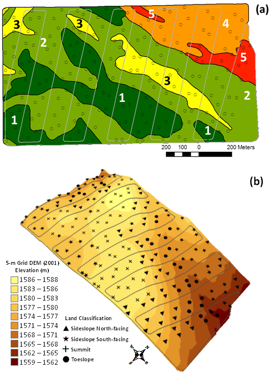
Figure 4. Soils map and Land Surface Elevation of the Scott Field. (a) Soils map of the Scott Field showing point soil sample locations and the crop management strips. Soil unit abbreviations are: 1 = Wagonwheel loam 0-2% slope, 2 = Wagonwheel loam 2-5% slope, 3 = Colby loam 5 - 9% slope, 4 = Kim fine sandy loam 2 - 5% slope, 5 = Kim fine sandy loam 5-9% slope; and (b) land surface elevation of the field based on the 2001 5-m grid digital elevation model (DEM), with soil sample locations shown by land classification (from Sherrod et al.)6.
The first ground surface elevation survey was collected by RTKGPS in 2001 to produce a digital elevation model (DEM) for the site. In conjunction with McCutcheon et al., an intensive soil sample (Figure 4a) was also performed in 2001, from which surface soil CaCO3 were analyzed by a modified pressure-calcimeter method30,31. Visually evident erosion and deposition occurring over the subsequent decade due to wind, predominantly from the northwest, and rainfall-runoff events prompted a second RTKGPS elevation survey in 2009 (with a portion of the field completed in 2010). Comparison of the new DEM to the original 2001 DEM via a DEM of Difference map32 confirmed significant erosion and deposition, displaying patterns which suggested multiple controlling factors for these processes (Figure 5). Given the substantial surface soil redistribution at the site and the historical soil CaCO3 data, the 2001 soil sample was repeated in 2012 to test a conceptual model of hydropedological processes6, as described in the previous section.
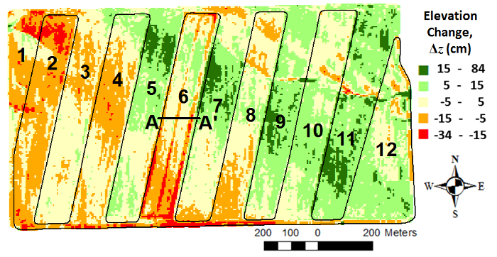
Figure 5. Map of Changes (2001-2009*) in Land Surface elevation (Δz) on a 5-m Grid within the Scott Field in Northeastern Colorado. Crop strip numbers are labeled over the alternating winter-wheat-fallow cropping system, and section A-A' is shown (details given in Figure 11). *Strips 2, 4, 6, 8 surveyed in 2010 to complete the 2009 DEM (from Sherrod et al.)6. Please click here to view a larger version of this figure.
Protocol
1. Land Surface Elevation Data Collection
- GPS calibration for site
- Locate or set a stable benchmark in a secure location at the survey site for use as the base station GPS for RTKGPS data collection.
- Set up base station for RTKGPS data collection at this local benchmark using best approximation of coordinates for the base station location (i.e., WAAS-corrected GPS position).
- With the rover GPS, visit at least three horizontal and vertical control point benchmarks within the radio communication limits of the RTKGPS (approximately 10 km radius) and record positions.
NOTE: Benchmarks described by the National Geodetic Survey can be searched online33 and were used here. - Given the measured and published coordinates of the control points, use RTKGPS field software to perform a site calibration34, solving for coordinates of local benchmark to be used as base station. Check that coordinate residuals (horizontal and vertical) for the control points are within tolerable limits (± 0.02 m for this calibration).
- GPS point data collection
- With base station GPS set on local benchmark and using local site calibration and field software, record RTKGPS position data into GPS data collector at approximately a 5-m horizontal spacing throughout the survey area.
- Collect data efficiently by mounting rover GPS antenna at a measured fixed height above the ground surface on a vehicle and driving transects through the area (Figure 6).
- For vehicle method, define transect endpoints to create parallel transects spaced 5 m apart. Import transect endpoints into GPS data collector for navigation of transects while driving. Collect points with the data collector automatically once per second while driving transects at approximately 5 m s-1 to obtain point data about every 5 m.
- Repeat point data collection at site as described above at later time (8 to 9 years later in this study) so that land surface elevation changes can be analyzed; the original GPS site calibration is used for all surveys and is not repeated.
- With base station GPS set on local benchmark and using local site calibration and field software, record RTKGPS position data into GPS data collector at approximately a 5-m horizontal spacing throughout the survey area.
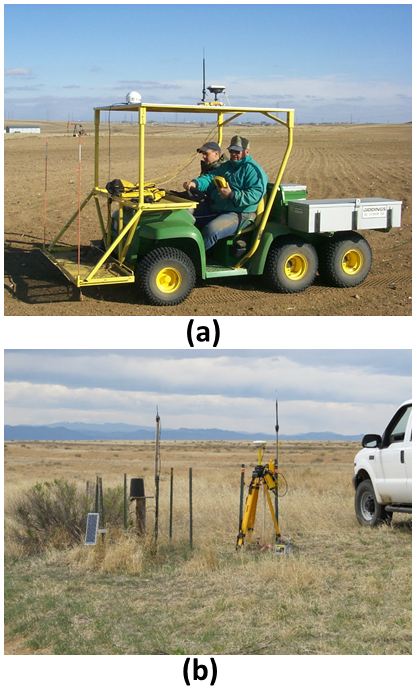
Figure 6. RTKGPS Elevation Surface Data Collection. RTKGPS elevation surface data is collected while driving a utility vehicle through the field (a), while real-time GPS corrections are provided by the on-site base station (b).
2. DEM Creation and Processing
- Creating the DEMs
- Import position data into GIS software and interpolate to a 5-m grid DEM. Using GIS software, cross-validate measured point elevations to interpolated elevation values and choose an interpolation method that minimizes these cross-validation errors.
NOTE: Ordinary kriging with a Gaussian semivariogram model was the optimal interpolation method for the elevation data at this site. Cross-validation also provides a measure of elevation accuracy for the survey method35. - Repeat 2.1.1 for second set of position data to create second DEM.
- Import position data into GIS software and interpolate to a 5-m grid DEM. Using GIS software, cross-validate measured point elevations to interpolated elevation values and choose an interpolation method that minimizes these cross-validation errors.
- Mapping DEM change
- Using a raster calculator tool in GIS, subtract the most recent DEM from the original DEM to create a raster map of DEM change (Figure 5), where negative values of elevation change represent erosion and positive values represent deposition.
- Land Classification
- Compute land surface topographic attributes (slope, aspect, contributing area) from the first grid DEM using DEM processing software.
- Classify land areas as summit, sideslope, or toeslope based on slope and contributing area of each DEM grid cell.
NOTE: Summits are represented by low slopes and low contributing areas. Sideslopes are represented by high slopes and intermediate contributing areas. Toeslopes are represented by low slopes and high contributing areas. Slope and contributing area values defining these classifications will depend on the land surface topography at the site and are qualitatively chosen to give the desired representation of each classification area for a particular site. - Divide sideslope areas by the two dominant aspects, north-facing and south-facing at this site.
3. Soil Sampling
- Sample Planning
- Reference maps in GIS to plan soil sample locations. Choose a number of locations to adequately represent all landscape positions.
- Upload sample location coordinates to the GPS data collector so that sample sites can be located in the field.
- Use prior knowledge of soils at the site to guide decisions of sample depth increments in order to capture CaCO3 variability. Pre-label sealable plastic bags to indicate sample location and depth increment.
- Field Sampling
- Drive to the sample sites with a utility vehicle equipped with a hydraulic soil coring machine and the RTKGPS rover antenna for navigation.
- Using soil coring machine and sampling tube for desired soil core diameter (5.1 cm in this study), extract soil core from each sample location (Figure 7).
NOTE: The number of cores extracted at each location, as well as the soil core depth and increments varied in this study. In 2001, a single core to a depth of 90 cm was taken and divided into 30 cm increments. In 2012, two soil cores were taken (within 1 m of the corresponding 2001 sample) to a depth of 30 cm and divided into 15 cm increments, with the two cores being aggregated for analyses. The 2012 method is recommended. - Record RTKGPS position data (x, y, z) at each sample location.
- Cut the soil core into desired depth increments and transfer into pre-labelled sealable plastic bags and then place in coolers for transport back to the laboratory.
- Repeat field sampling after significant erosion and/or deposition has occurred (11 years between samples in this study).
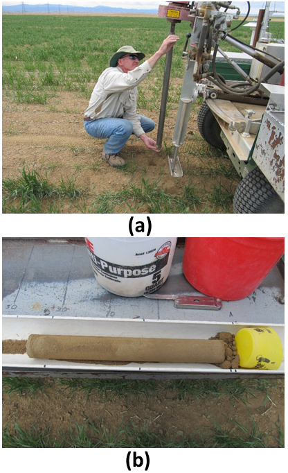
Figure 7. Soil Sampling. Soil sample locations are navigated to using a GPS-guided utility vehicle equipped with a hydraulic soil coring machine (a) so that soil cores can be extracted (b) and divided into desired depth increments.
- Position Data Processing
- Measure differences in elevations recorded at each soil sample location between the two sample dates (198 locations sampled in 2001 and 2012 in this study).
NOTE: Elevations for 2001 were taken from the 2001 DEM since point elevations were not recorded at the time of soil sampling. Positive changes in elevation > 0.05 m are considered depositional sites, while negative changes in elevation < -0.05 m are considered erosional sites. - Classify each sample location as summit, North-facing sideslope, South-facing sideslope, or toeslope based on the DEM processing (see Protocol 2.3.2); classification at a single location, as defined by the slope and contributing area criteria, may be reclassified to match the dominant classification of surrounding points.
- Use spatial joining tools in GIS software to assign sample locations to other spatial data layers used for analyses (management strip and soil mapping unit).
- Measure differences in elevations recorded at each soil sample location between the two sample dates (198 locations sampled in 2001 and 2012 in this study).
4. Soils Analyses
- Soil Sample Preparation
- Dry soil samples from the field at 60 °C in a laboratory oven overnight.
- Grind oven-dried soils to pass through a 2 mm sieve using a motorized grinder or a mortar and pestle.
- Modified Pressure-Calcimeter Apparatus Setup
- Set up the modified pressure-calcimeter apparatus (Figure 8) by connecting a pressure transducer (0 - 105 kPa range, 0.03 - 5 V DC output) to a power supply with 14 gauge wire and a digital voltmeter wired in line to monitor output from the transducer.
- Attach 9.5-mm ID tubing to the base of the pressure transducer and connect tubing to an 18 gauge Luer lock hypodermic needle with a particle filter (0.6 µm) in the middle to collect any reflux from reaching the pressure transducer.
- Use serum bottles as reaction vessels connected to the pressure transducer (Figure 9). Determine the size of the serum bottle to use by wetting a metal tablespoon with water and adding approximately 5 mL of soil that you expect to have high CaCO3 concentration. Pipet 1 mL of 0.5 N H2SO4 to this soil and observe effervescence.
- If effervescence is high, then assume greater than 15% CaCO3 concentration and use a 100 mL serum bottle as the reaction vessel, otherwise use a 20 mL serum bottle.
- Set up the modified pressure-calcimeter apparatus (Figure 8) by connecting a pressure transducer (0 - 105 kPa range, 0.03 - 5 V DC output) to a power supply with 14 gauge wire and a digital voltmeter wired in line to monitor output from the transducer.
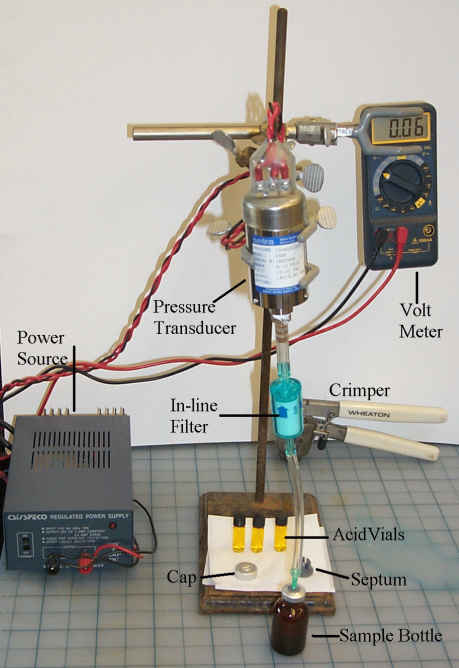
Figure 8. Modified Pressure-calcimeter Apparatus. The modified pressure-calcimeter apparatus uses a serum bottle as the reaction vessel and a pressure transducer wired to a voltage meter to output the signal (from Sherrod et al.)30.
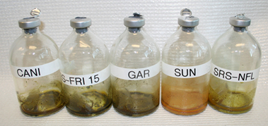
Figure 9. Reaction Vessels for the Modified Pressure-calcimeter Method. Reaction vessels for the modified pressure-calcimeter method are serum bottles containing a 0.5 dram vial with 2 mL acid reagent and a 1 g soil sample.
- Carbonate Measurement
- Place a 1 g subsample of the prepared soil (see Protocol 4.1) into a labelled reaction vessel. For soils containing greater than 50% CaCO3, use only 0.5 g of soil.
- Pipet 2 mL of acid reagent (6 N HCI containing 3% FeCL2O4H2O) into a 0.5 g glass vial. Place vial into reaction vessel gently so that the solution contents do not spill out by tilting the reaction vessel almost to the side position.
- While keeping the reaction vessel containing the soil sample and acid vial tilted, seal with gray butyl rubber stoppers and crimp with aluminum sealing ring.
- Shake reaction vessel with a swirling motion to insure complete mixing of soil with acid. Place the reaction vessel on the lab bench and let the reaction proceed for at least 2 hr.
- While waiting for reaction vessels to complete, determine a standard curve by measuring voltages of known CaCO3 concentrations using the same reaction vessel setup as soil samples (Figure 10). Mix 100% CaCO3 with glass beads or sand on a weight percentage basis to create known CaCO3 concentrations. Include a blank sample without CaCO3.
- After soil sample reactions are complete, pierce the rubber septum of the reaction vessel with an 18 gauge hypodermic needle and record voltage output by the pressure transducer.
- Solve for CaCO3 percentage given the measured voltage and the equation determined from the standard curve (Figure 10a).
NOTE: Increase in pressure produced by release of CO2 is linearly related to the concentration of CaCO3 present in the soil such that: % CaCO3 = (regression coefficient * change in pressure in volts) + intercept.
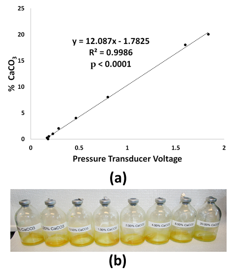
Figure 10. CaCO3 Measurement. (a) A standard curve for CaCO3 is created using the voltage readings from the pressure transducer based on known percentages of CaCO3 (b) mixed with powder glass beads or sand.
5. Statistical Analyses
- Define two dependent variables as the change in ground surface elevations and soil surface layer CaCO3 concentrations from the first to second sample dates (2001 to 2012 in this study). Define independent or explanatory variables as management (odd- or even- numbered strip), individual strips, west or east block of strips, soil mapping unit, landscape classification, and erosional/depositional classification.
- Perform correlation analysis and analysis of variance to statistically quantify relationships between variables. Perform analyses in any preferred statistical package.
Results
Mapping DEM differences from 2001 and 2009 reveals erosion (red) and deposition (green) over that 8-year period, with decimeter-level changes in elevation over most areas (Figure 5). At the field-scale, erosion is dominant in the west and southwest, while deposition is seen along a northwest to southeast diagonal band on the eastern side of the field. Alternating bands of erosion and deposition are seen at the management-scale, often with abrupt changes at th...
Discussion
Mapped changes in elevation (Figure 5) illustrate significant erosion and deposition on an agricultural field and spatial patterns indicative of multiple controlling factors over multiple scales. From field scale patterns associated with wind, down to fine scale dendritic patterns produced by water flow, processes relevant to this study are discernable. The level of elevation change detection provided by repeated RTKGPS ground surveys appears optimal. Finer detection levels, as provided by T...
Disclosures
The authors have nothing to disclose.
Acknowledgements
The field study site is on a farm managed by David Drake and we thank him for his cooperation during this long-term research. We also thank Mike Murphy for his many years of field work on this project and Robin Montenieri for her help with graphics used in this paper.
Materials
| Name | Company | Catalog Number | Comments |
| Real-time kinematic GPS system | Trimble | Model 5800 | |
| GPS field data collector | Trimble | Model TSC2 | |
| GPS field software | Trimble | Trimble Access (Trimble Survey Controller used in 2001 for site calibration but this software is no longer supported) | |
| Hydraulic soil coring machine | Giddings Machine Company | ||
| Utility vehicle | John Deere | Gator 6x4 | |
| GIS software | ESRI | ArcGIS for Desktop with Spatial Analyst and Geostatistical Analyst Extensions | |
| Statistical software | SAS | SAS Institute Inc. | |
| Pressure transducer 0-105 kPa | Serta | Model 280E | Setra Systems, In., Boxborough, MA |
| Volt meter | WaveTek | 5XL | Digital meter set to read volts |
| Serum Bottles | Wheaton | 223747 | 100 mL |
| Serum Bottles | Wheaton | 223762 | 20 mL |
| Sealing Cap 20 mm Aluminum | Wheaton | 224183-01 | Case of 1,000 |
| 20 mm gray butyl stopper (2-prong) | Wheaton | 224100-192 | Septum; Case of 1,000 |
| Hand crimper | Wheaton | W225303 | 20 mm size |
| Hand Decapper | Wheaton | W225353 | 20 mm size |
| Acid vials | Wheaton | 224881 | 0.50 dram size (2-mL) |
| Power supply | SR Components | DDU240060 | Class 2 Transformer AC adaptor; Input 120VAC , Output 24VDC |
| Calcium carbonate | Fisher | 471-34-1 | 500 g of 100% w/w CaCO3 |
References
- Freebairn, D. M. Erosion control - some observations on the role of soil conservation structures and conservation. Nat. Res. Mgt. 7 (1), 8-13 (2004).
- Garcia-Orenes, F., Roldan, A., Mataix-Solera, J., Cerda, A., Campoy, M., Arcenegui, V., Caravaca, F. Soil structural stability and erosion rates influenced by agricultural management practices in a semi-arid Mediterranean agro-ecosystem. Soil Use and Mgt. 28, 571-579 (2012).
- Hass, H. J., Willis, W. O., Bond, J. J. General relationships and conclusions. Summer Fallow in the Western United States. USDA-ARS Conserv. Res. Rpt. No. 17. , 149-160 (1974).
- Montgomery, D. R. Soil erosion and agricultural sustainability. Proc. of the Nat. Acad. of Sci. of the USA. 104 (33), 13268-13272 (2007).
- Skidmore, E. L., Layton, J. B., Armbrust, D. V., Hooker, M. L. Soil physical properties as influenced by cropping and residue management. Soil Sci. Soc. of Am. J. 50 (2), 415-419 (1986).
- Sherrod, L. A., Erskine, R. H., Green, T. R. Spatial patterns and cross-correlations of temporal changes in soil carbonates and surface elevation in a winter wheat-fallow cropping system. Soil Sci. Soc. of Am. J. 79 (2), 417-427 (2015).
- Stroosnijder, L. Measurement of erosion: Is it possible?. Catena. 64 (2-3), 162-173 (2005).
- Dąbek, P., Żmuda, R., Ćmielewski, B., Szczepański, J. Analysis of water erosion processes using terrestrial laser scanning. Acta Geodynam. Et Geomat. 11 (1), 45-52 (2014).
- Day, S. S., Gran, K. B., Belmont, P., Wawrzyniec, T. Measuring bluff erosion part 1: terrestrial laser scanning methods for change detection. Earth Surf. Proc. and Landforms. 38 (10), 1055-1067 (2013).
- Eltner, A., Baumgart, P. Accuracy constraints of terrestrial Lidar data for soil erosion measurement: Application to a Mediterranean field plot. Geomorph. 245, 243-254 (2015).
- Letortu, P., et al. Retreat rates, modalities and agents responsible for erosion along the coastal chalk cliffs of Upper Normandy: The contribution of terrestrial laser scanning. Geomorph. 245, 3-14 (2015).
- Longoni, L., et al. Monitoring Riverbank Erosion in Mountain Catchments Using Terrestrial Laser Scanning. Rem. Sens. 8 (3), 241 (2016).
- Meijer, A. D., Heitman, J. L., White, J. G., Austin, R. E. Measuring erosion in long-term tillage plots using ground-based lidar. Soil & Till. Res. 126, 1-10 (2013).
- Rengers, F. K., Tucker, G. E., Moody, J. A., Ebel, B. A. Illuminating wildfire erosion and deposition patterns with repeat terrestrial lidar. J. of Geophys. Res.-Earth Surf. 121 (3), 588-608 (2016).
- Schubert, J. E., Gallien, T. W., Majd, M. S., Sanders, B. E. Terrestrial Laser Scanning of Anthropogenic Beach Berm Erosion and Overtopping. J. of Coast. Res. 31 (1), 47-60 (2015).
- Stenberg, L., et al. Evaluation of erosion and surface roughness in peatland forest ditches using pin meter measurements and terrestrial laser scanning. Earth Surf. Proc. and Landforms. 41 (10), 1299-1311 (2016).
- Croke, J., Todd, P., Thompson, C., Watson, F., Denham, R., Khanal, G. The use of multi temporal LiDAR to assess basin-scale erosion and deposition following the catastrophic January 2011 Lockyer flood, SE Queensland, Australia. Geomorph. 184, 111-126 (2013).
- Earlie, C., Masselink, G., Russell, P., Shail, R. Sensitivity analysis of the methodology for quantifying cliff erosion using airborne LiDAR - examples from Cornwall, UK. J. of Coast. Res. Spec. Iss. 65, 470-475 (2013).
- Kessler, A. C., Gupta, S. C., Dolliver, H. A. S., Thoma, D. P. Lidar Quantification of Bank Erosion in Blue Earth County, Minnesota. J. of Env. Quality. 41 (1), 197-207 (2012).
- Pye, K., Blott, S. J. Assessment of beach and dune erosion and accretion using LiDAR: Impact of the stormy 2013-14 winter and longer term trends on the Sefton Coast, UK. Geomorph. 266, 146-167 (2016).
- Thoma, D. P., Gupta, S. C., Bauer, M. E., Kirchoff, C. E. Airborne laser scanning for riverbank erosion assessment. Rem. Sens. of Env. 95 (4), 493-501 (2005).
- Zhang, C. L., Yang, S., Pan, X. H., Zhang, J. Q. Estimation of farmland soil wind erosion using RTK GPS measurements and the Cs-137 technique: A case study in Kangbao County, Hebei province, northern China. Soil & Till. Res. 112 (2), 140-148 (2011).
- Neugirg, F., et al. Erosion processes in calanchi in the Upper Orcia Valley, Southern Tuscany, Italy based on multitemporal high-resolution terrestrial LiDAR and UAV surveys. Geomorph. 269, 8-22 (2016).
- Pineux, N., et al. Can DEM time series produced by UAV be used to quantify diffuse erosion in an agricultural watershed?. Geomorph. 280, 122-136 (2017).
- Bremer, M., Sass, O. Combining airborne and terrestrial laser scanning for quantifying erosion and deposition by a debris flow event. Geomorph. 138 (1), 49-60 (2012).
- Day, S. S., Gran, K. B., Belmont, P., Wawrzyniec, T. Measuring bluff erosion part 2: pairing aerial photographs and terrestrial laser scanning to create a watershed scale sediment budget. Earth Surf. Proc. and Landforms. 38 (10), 1068-1082 (2013).
- De Rose, R. C., Basher, L. R. Measurement of river bank and cliff erosion from sequential LIDAR and historical aerial photography. Geomorph. 126 (1-2), 132-147 (2011).
- Perroy, R. L., Bookhagen, B., Asner, G. P., Chadwick, O. A. Comparison of gully erosion estimates using airborne and ground-based LiDAR on Santa Cruz Island, California. Geomorph. 118 (3-4), 288-300 (2010).
- Loeppert, R. H., Suarez, D. L., Sparks, D. L., et al. Carbonate and Gypsum. Methods of Soil Analysis. Part 3. Chemical Methods. , 437-474 (1996).
- Sherrod, L. A., Dunn, G., Peterson, G. A., Kilberg, R. L. Inorganic carbon analysis by modified pressure-calcimeter method. Soil Sci. Soc. of Am. J. 66 (1), 299-305 (2002).
- McCutcheon, M. C., Farahani, H. J., Stednick, J. D., Buchleiter, G. W., Green, T. R. Effect of soil water on apparent soil electrical conductivity and texture relationships in a dryland field. Biosyst. Eng. 94 (1), 19-32 (2006).
- Wheaton, J. M., Brasington, J., Darby, S. E., Sear, D. A. Accounting for uncertainty in DEMs from repeat topographic surveys: improved sediment budgets. Earth Surf. Proc. and Landforms. 35 (2), 136-156 (2010).
- . Survey Marks and Datasheets Available from: https://www.ngs.noaa.gov/datasheets/ (2017)
- Trimble Inc. . Trimble Access Software – General Survey. Version 1.60. Revision A. , (2011).
- Erskine, R. H., Green, T. R., Ramirez, J. A., MacDonald, L. H. Digital elevation accuracy and grid cell size: effects on estimated terrain attributes. Soil Sci. Soc. of Am. J. 71, 1371-1380 (2007).
Reprints and Permissions
Request permission to reuse the text or figures of this JoVE article
Request PermissionThis article has been published
Video Coming Soon
Copyright © 2025 MyJoVE Corporation. All rights reserved