
Using Topographic Maps to Generate Topographic Profiles
Overview
Source: Laboratory of Alan Lester - University of Colorado Boulder
Topographic maps are "plan-view" representations of Earth's three-dimensional surface. They are a standard type of map-view that provides an overhead, or aerial, perspective.
Among the defining features of a topographic map are the contour lines that indicate locations of constant elevation. The elevation interval between the contour lines is dependent on the level of detail provided by the map and the kind of topography present. For example, regions with significant topographic variation might require contour lines separated by 40-100 ft., whereas generally flat-lying regions with little topographic variation might have more broadly separated 10-20 ft. contours.
To an experienced user of such maps, the patterns made by the topographic lines are representative of various landform patterns, such as ridges, valleys, hills, and plateaus.
Principles
Although modern three-dimensional imagery (e.g. digital elevation models, Google Earth) can be useful as a means to get a rapid and general impression of a landscape, these images are subject to distortion and cannot be used to extract quantitative elevation data. In contrast, a topographic map can provide a distortion-free source of information regarding altitudes for discrete points over the entire map area.
The ability to extract dependable elevation data for any point on the topographic map allows for the construction of topographic profiles. These are cross-sectional views (perpendicular to the standard plan-view or map-view) that define a continuous series of elevations along a line, connecting two points on the map. The topographic profile is a graph of elevation (y-axis) versus distance (x-axis) between the two defined points on the topographic map. This graphical profile allows one to effectively see the land surface from an "edge-on" view that shows how the land surface rises and falls along a hypothetical line, joining two points on the map. The perspective of the topographic profile is very useful; it provides a starting point for making geologic cross-sections that project rock structures or layers into the subsurface.
Procedure
- Obtain a topographic map.
- Establish a line between two specified points on the map. Call these points, A-A', or X-X', or Y-Y'.
- Lay the edge of a paper strip along the cross-section line, marking the two points, A-A', with tick marks.
- Place a tick mark where each of the contour lines intersects the line of the cross-section. Add notations that indicate the elevations of those contour lines.
- If there is substantial topographic variation along the chosen line, A-A', start by only marking the intersection of the line with the major contours. The major contours (also called index contours) are those that show up on the map as bold, slightly heavier lines.
- For example, major contours on a 7.5-minute quadrangle map are typically used to indicate 200 ft. intervals on the map, with the standard contour lines representing 40 ft. intervals. This means that between every major contour, there are 4 standard contours (representing 5 steps in elevation to move from one major contour to the next).
- Along certain portions of the cross-section line, there may be steep topographic variation, and therefore, closely-spaced contour lines. Here, mark only the major contours. Where there is little topographic variation, mark all contours (where they intersect the cross-section line).
- If there is substantial topographic variation along the chosen line, A-A', start by only marking the intersection of the line with the major contours. The major contours (also called index contours) are those that show up on the map as bold, slightly heavier lines.
- Set the paper with the tick marks along the x-axis of a piece of graph paper. Transfer the elevation marks onto the y-axis with a dot.
- This generates a graph of elevation (y-axis) versus distance along the A-A' line.
- The scale of the x-axis is defined by the map itself. The scale of the y-axis can be chosen to be equivalent to the map scale (resulting in no vertical exaggeration), or it can be chosen such that the small elevation variations are effectively "stretched out" (resulting in vertical exaggeration).
- Smooth the profile by connecting the dots, recognizing that most topographic variation in the real world does not exist in abrupt steps.
Topographic profiles give a side-on view of the terrain of an area of interest.
Topographic maps are a standard map view that provides aerial perspective and three-dimensional representation of the Earth's surface. These can be used to generate side-on views of the land, also known as topographic profiles.
When planning roads, railroads, pipelines, or hiking trails, topographic profiles can be a valuable tool to inform the professional or recreational user of the terrain in a target area.
This video will illustrate the process of making topographic profiles from topographic maps.
Among the defining features of topographic maps are the contour lines, which notate elevation. These lines convey three-dimensional information, and can inform the map user of various landform patterns, such as ridges, valleys, hills, or plateaus.
In topographic mapping, maps produced can vary in detail and scale, often dependent on the subject terrain. The elevation interval between the contour lines is one aspect that may vary. For example, in regions with significant topographic variation, maps may use contour lines of 40 to 100 feet. In generally flat-lying areas with little variation, maps may use more broadly separated 10 to 20 foot contours.
The precise composition and ability to extract dependable elevation data for any point on the topographic map allows for construction of topographic profiles. These "side-on" cross-sectional views are constructed using a line established between points, and recording contours crossing this line.
The subsequent data is plotted as a graph of elevation, with elevation plotted on the Y-axis, and the contour crossings along the X-axis. When these points are joined, this allows the user to see how the surface rises and falls along this hypothetical line.
Depending on the intended use of the map, vertical exaggeration can be applied to the Y-axis. This can be beneficial in scenarios where the topographic profile is being utilized to show the ruggedness of the terrain. In scenarios where the primary use of the topographic profile is to project geologic features or cross-sections, vertical exaggeration is best avoided.
Topographic profiles can be extremely useful, and provide a starting point for making geologic cross-sections that project rock structures or layers into the subsurface. In a very general sense, we find that ridges are composed of resistant rocks and valleys are composed of less-resistant, easily eroded rocks.
Now that we are familiar with topographic maps and making topographic profiles, let's take a look at how this is carried out.
The first step in making a topographic profile is to obtain a topographic map. These can be generated by the scientist, or gathered from a geological survey agency. Once an appropriate map has been selected, topographic profiling can be started.
Establish a line between two points that intersects the region of interest on the map. These should be labeled as A-A'. Take a strip of paper, and lay it along the cross section line between the two points. On the strip of paper, place a tick mark where each of the contour lines intersects the line of the paper cross-section. Add notations indicating the elevations of those contour lines. Where there is little topographic variation, mark all contours. If there is substantial topographic variation along the chosen line, begin by only marking the intersection of the major, or "index" contours. These are seen in bold on the map.
On graph paper, draw the region of interest. Choose a scale for the y-axis with or without exaggeration. Set the tick marks along the x-axis and transfer each elevation mark onto the graph with a dot. This generates a graph of elevation versus distance along the A-A' line. Connect these dots to make a continuous line.
The map defines the scale of the x-axis, but the Y-axis can be chosen to show a realistic view, or one that accentuates the local topography to demonstrate rugged terrain.
The ability to visualize local terrain is important in a variety of applications.
Evaluating the ruggedness or steepness of a terrain can be useful in assessing the difficulty of traversing a particular area. This can be applicable in different ways for different modes of transport such as hiking, biking, or driving. Field work for geological or biological surveys may require making a transect through an area for the purpose of taking measurements or collecting samples. Topographic profiles can inform field scientists of the feasibility and difficulty of sampling in different regions and facilitate planning of an appropriate transect.
Topographic profiles are the land-surface basis for constructing geologic cross-sections. These sections are a graphical projection of surface rock or soil layers into the subsurface, and provide a side view of the Earth's interior crucial to interpreting all kinds of geologic features. These can be used for many applications, including locating likely sources of ground water reservoirs, possible oil and gas pockets, or regions of folding or faulting.
Most topography on Earth is a consequence of the interplay between erosion and uplift, which is caused by volcanism, tectonism, tidal forcing, and impacts. Detailed analyses of topographic variations are a critical part of assessing terrain evolution.
You've just watched JoVE's introduction to topographic maps and profiles. You should now understand the importance of topographic maps, how to make topographic profiles, and how these profiles can be useful to geologists and communities as a whole.
Thanks for watching!
Results
Once properly smoothed and checked against the map itself (for elevation details between points), the resulting topographic profile is a representation of the highs and lows of a landscape, between the defined points.
When topographic profiles are used as a base for projections of geologic features into the subsurface, it's generally best to avoid vertical exaggeration - in other words, the horizontal and vertical axes should have the same scale. However, when there is very little vertical variation across the topographic profile line, it might be useful (in order to visualize topography) to have a different vertical scale, effectively stretching out the vertical topographic variations.
The degree of vertical exaggeration is equal to the vertical fractional scale divided by the horizontal fractional scale. For example, if one is using a typical U.S. Geological Survey topographic map with a horizontal scale of 1:24,000 (1 in. on the map represents 24,000 in. in the real world) and a chosen vertical scale of 1:24,00 (1 in. on the vertical scale represents 2,400 in. of vertical change), then the vertical exaggeration is simply 1/2,400 divided by 1/24,000 which equals 10X vertical exaggeration.
Some vertical exaggeration is often useful, particularly when the topographic profile is being used primarily to show the ruggedness of the terrain. As per the previous example, on a 1:24,000 map (the scale generally used on standard USGS 7.5-minute quadrangle maps), 1 in. on the lateral x-axis of the topographic profile represents 2,000 ft., and these maps (depending on latitude) are around 6 by 8 mi. in total (east-west versus north-south) dimension. But in many map regions, there is substantially less than 2,000 ft. (i.e., 1 in.) of vertical relief over the entire map area; therefore, a non-exaggerated profile shows very little variation on the y-axis, and an exaggerated profile may be desired.
For the purpose of making geologic cross-sections, where the main interest is to project rock layers into the subsurface (and less significance is given to the surficial topographic variation), it is best to use a non-exaggerated topographic profile as the base from which to make the projections. With a non-exaggerated profile, the rock layer dip-angles do not need to be modified. This is discussed in greater detail in the "Making a Geologic Cross Section" video.
Application and Summary
A topographic profile provides a visual representation of the topographic highs and lows across a line segment on a map, from one point to another. Such profiles are used to evaluate the "ruggedness" of terrain, which is useful in assessing the difficulty of travel (driving, biking, or hiking as transportation modes for field-work) (Figure 1). Sometimes fieldwork requires making a transect through a region for the purpose of collecting samples or making geophysical measurements. A topographic profile can tell the field-scientist something about the difficulty and feasibility of such a traverse.
Nearly all topography on planet earth is a consequence of the interplay between uplift (whether generated by volcanism, tectonism, tidal forcing, impact, etc.) and erosion. As such, detailed analyses of topographic variations are a critical part of assessing geomorphic models related to terrain evolution. For example, if a geologist wants to know why a river or glacier system exhibits significant gradient variation along its course, topographic profiles are the primary means to quantify these changes (Figure 2). Topographic steps and variations can be used to indicate the relative resistance of rocks and soils to erosion; low areas being of greater susceptibility to erosion.
Topographic profiles are also the land-surface base for making geologic cross-sections (see video Making a Geologic Cross Section). A cross-section is a graphical projection of surface rock or soil layers into the subsurface. This side-view of the earth's interior is crucial to interpreting all kinds of geologic features. Geologists use cross-sectional views of the subsurface to interpret the location of ground-water reservoirs and flow regime, identify possible oil and gas pockets, and model mechanisms for rock deformation (folding and faulting).
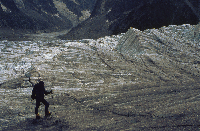
Figure 1. An example of terrain that would require topographic evaluation. Please click here to view a larger version of this figure.
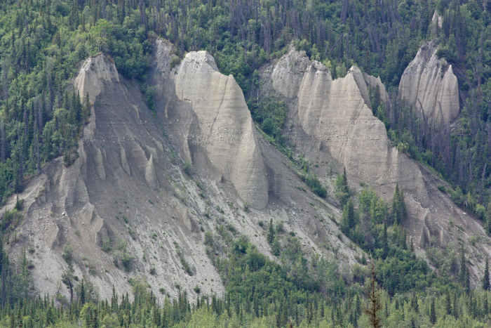
Figure 2. Deep, eroding glaciofluvial deposits alongside the Matanuska River, Alaska. Please click here to view a larger version of this figure.
Tags
Skip to...
Videos from this collection:

Now Playing
Using Topographic Maps to Generate Topographic Profiles
Earth Science
32.2K Views

Determining Spatial Orientation of Rock Layers with the Brunton Compass
Earth Science
25.8K Views

Making a Geologic Cross Section
Earth Science
47.3K Views

Physical Properties Of Minerals I: Crystals and Cleavage
Earth Science
51.8K Views

Physical Properties Of Minerals II: Polymineralic Analysis
Earth Science
38.2K Views

Igneous Volcanic Rock
Earth Science
39.9K Views

Igneous Intrusive Rock
Earth Science
32.4K Views

An Overview of bGDGT Biomarker Analysis for Paleoclimatology
Earth Science
5.4K Views

An Overview of Alkenone Biomarker Analysis for Paleothermometry
Earth Science
7.2K Views

Sonication Extraction of Lipid Biomarkers from Sediment
Earth Science
9.9K Views

Soxhlet Extraction of Lipid Biomarkers from Sediment
Earth Science
18.6K Views

Extraction of Biomarkers from Sediments - Accelerated Solvent Extraction
Earth Science
10.1K Views

Conversion of Fatty Acid Methyl Esters by Saponification for Uk'37 Paleothermometry
Earth Science
10.1K Views

Purification of a Total Lipid Extract with Column Chromatography
Earth Science
12.5K Views

Removal of Branched and Cyclic Compounds by Urea Adduction for Uk'37 Paleothermometry
Earth Science
6.4K Views
Copyright © 2025 MyJoVE Corporation. All rights reserved