Uso de SIG para Investigar Florestas Urbanas
Visão Geral
Fonte: Laboratórios de Margaret Workman e Kimberly Frye - Universidade Depaul
As florestas urbanas incluem parques urbanos, árvores de rua, avenidas paisagísticas, jardins públicos, passeios fluviais e costeiros, vias verdes, corredores fluviais, pântanos, preservações naturais, áreas naturais, abrigos de árvores e árvores de trabalho em locais industriais de brownfield. A história das árvores urbanas começa com árvores como embelezamento paisagístico. Hoje, as árvores urbanas são vistas como componentes essenciais da infraestrutura urbana e críticas à vida humana como alimentos, moradias e outros serviços públicos. As árvores urbanas são agora valorizadas pelos serviços ecossistêmicos que prestam (por exemplo, prevenindo erosão, remoção de poluentes atmosféricos, oxigênio, sombra, etc.). No entanto, para fazer uso eficiente desses benefícios, as árvores devem atingir a maturidade, pois o número e o tamanho das folhas afetam diretamente a capacidade de uma árvore de fornecer serviços ecossistêmicos. A silvicultura urbana teve que desenvolver seus próprios métodos florestais para atender às necessidades e desafios exclusivos das árvores urbanas em comparação com suas contrapartes florestais.
O seguinte trecho do Serviço Florestal do USDA ilustra a perspectiva e as políticas de árvores urbanas do governo federal:
As florestas urbanas são ecossistemas dinâmicos que fornecem serviços ambientais necessários, limpando ar e água, ajudando a controlar as águas pluvais e conservando energia. Eles adicionam forma, estrutura, beleza e espaço de respiração ao design urbano, reduzem o ruído, usam separadamente incompatíveis, fornecem lugares para recriar, fortalecer a coesão social, alavancar a revitalização da comunidade e agregar valor econômico às nossas comunidades... Este sistema natural de suporte à vida sustenta ar e água limpos, biodiversidade, habitat, ninhos e corredores de viagem para a vida selvagem, e conecta as pessoas à natureza.
O manejo de árvores urbanas é uma prática interdisciplinar que envolve arquitetura, paisagismo, planejamento, desenvolvimento, horticultura, etc. Uma disciplina particular envolvida na silvicultura é a geografia, especialmente através do uso de sistemas de informação geográfica (SIG). GIS é um nome amplo que abrange qualquer tipo de banco de dados que contenha dados geográficos ou espaciais que possam ser usados para criar representações visuais geradas por computador (por exemplo,mapas). O GIS permite uma ampla coleta e gerenciamento de dados por meio de interfaces de usuário cada vez melhores, aumentando a qualidade amigável do usuário de conjuntos muito grandes de informações que podem ser acessadas por muitos usuários. Os aplicativos GIS variam de software livre e protocolos de acesso aberto, como o Google Earth, a sistemas proprietários, como o ESRI ArcGIS. O uso do SIG para criar e armazenar informações geográficas também permite uma fácil manutenção de dados, pois os mapas podem ser rapidamente atualizados adicionando novas informações ao banco de dados e regenerando a saída visual.
Procedimento
1. Coleta de dados com receptor GPS e fita dbh
- Em um local aberto ao ar livre, ligue o receptor GPS pressionando o botão de alimentação. Aguarde 2-3 min enquanto o receptor se conecta a um mínimo de três satélites.
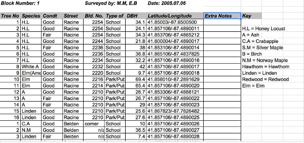
- Caminhe até a área de pesquisa para coleta de dados. Pesquise um segmento de blocos da cidade de cada vez e número as árvores da parkway em uma ficha técnica(Figura 1),redefinindo a numeração no início de cada segmento de bloco.
- Em cada árvore do levantamento, reg
Resultados
A Figura 1 mostra os resultados representativos para árvores de rua encontradas em um bloco, e um mapa a partir de dados florestais urbanos inseridos no SIG pode ser visto na Figura 4.
Os resultados para o uso da Calculadora de Benefícios da Árvore podem ser encontrados na Tabela 2. Esta calculadora fornece uma estimativa dos benefícios que as árvores individuais do lado da rua proporcionam. Uma vez que os dados da investigação de campo...
Aplicação e Resumo
Uma vez inseridos em um SIG, os dados florestais podem ser analisados usando estatísticas geoespaciais. Por exemplo, um teste estatístico geoespacial I de Moran é uma estatística amplamente utilizada que analisa um agrupamento geográfico significativo de variáveis de saúde. Moran's I pode ser usado para dados florestais para relatar valores dbh localizados em determinadas áreas, indicando diferentes taxas de crescimento de árvores em diferentes locais da floresta. Se o agrupamento for significa...
Pular para...
Vídeos desta coleção:

Now Playing
Uso de SIG para Investigar Florestas Urbanas
Environmental Science
12.6K Visualizações

Identificação de árvores: como usar uma chave dicotômica
Environmental Science
81.1K Visualizações

Levantamento de Árvores: Método de Amostragem Trimestral Centrada em Pontos
Environmental Science
49.4K Visualizações

Células de combustível de membrana de troca de prótons
Environmental Science
22.0K Visualizações

Biocombustíveis: Produzindo Etanol a partir de Material Celulósico
Environmental Science
53.1K Visualizações

Testes para alimentos geneticamente modificados
Environmental Science
89.6K Visualizações

Turbidez e Sólidos Totais em Águas Superficiais
Environmental Science
35.8K Visualizações

Oxigênio dissolvido em Águas Superficiais
Environmental Science
55.6K Visualizações

Nutrientes em Ecossistemas Aquáticos
Environmental Science
38.8K Visualizações

Medição de Ozônio Troposférico
Environmental Science
26.4K Visualizações

Determinação de NOx no escapamento do automóvel usando espectroscopia UV-VIS
Environmental Science
30.0K Visualizações

Análise de chumbo do solo usando espectroscopia de absorção atômica
Environmental Science
125.3K Visualizações

Análise de Carbono e Nitrogênio de Amostras Ambientais
Environmental Science
29.4K Visualizações

Análise de Nutrientes do Solo: Nitrogênio, Fósforo e Potássio
Environmental Science
215.7K Visualizações

Análise de Populações de Minhocas no Solo
Environmental Science
16.5K Visualizações
Copyright © 2025 MyJoVE Corporation. Todos os direitos reservados